Coastal Monitoring and NB-IoT: A Brief Overview
 Author: Daisy Curtis
There are different subcategories within IoT network systems including Low-Powered Wide Area Networks (LPWANs) and Wireless Sensor Networks (WSNs). LPWANs enable constrained IoT devices to wirelessly communicate over long distances (in the order of several kilometres). An LPWAN is typically structured following a star topology where the devices operate independently from their peers. This category can be further subdivided into networks operating in the licensed spectrum, such as NB-IoT which operates over cellular networks, and networks operating in the unlicenced spectrum, such as LoRaWAN and SigFox. In contrast, in WSNs such as Zigbee, sensors communicate over much shorter distances (in the order of a few tens of metres), forming peer-to-peer mesh networks, thus enabling them to collaboratively carry out sensing tasks. Both types of IoT network systems are useful when undertaking environmental monitoring as they provide a means to collect data about a site in real-time (Senouci and Mellouk, 2016).
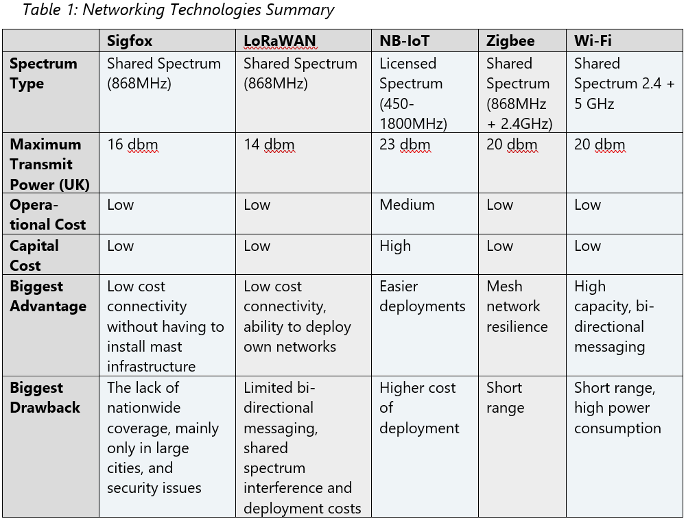
In this context, there are a number of different networking technologies, both LPWANs and WSNs, which can be employed. The below table provides an overall summary of the key types of networking technologies along with their biggest advantage and most significant drawback.
In the case of NB-IoT networks, deployment of this technology for coastal monitoring has been limited due to the cost efficiency and availability in comparison to other IoT network systems (see Table 1). However, with the expansion of NB-IoT coverage and as the cost reduces, the technology is becoming a relevant option for coastal monitoring. In order to understand the possibility of using NB-IoT for coastal monitoring, it is necessary to gain an insight into the work that is already occurring within this area. This document, therefore, provides an overview of studies which use IoT network systems for coastal monitoring, and also provides a snapshot of the work happening with NB-IoT networks on non-costal environmental monitoring. It is important to note that studies published in academic journals often do not specify the type of IoT network systems used. This work also primarily fits within the intermediate categories of the Technology Readiness Levels framework (5-6), or in other words, the focus is upon validating technology in a relevant environment or demonstrating its use in a relevant environment, rather than full scale commercial deployments.
Coastal Monitoring
There are a variety of techniques used to monitor coastal erosion and evolution, and the approach used depends on the form of coastal erosion being monitored and the types of data required. Methods for coastal monitoring range from establishing a series of sensors for infield monitoring to satellite imagery or structure-from-motion, with many of these methods used in conjunction with one another (Westoby et al, 2018; Bartolini et al 2018).
IoT network systems are comprised of sensor nodes which transmit data as part of a ‘transport layer’ or ‘network layer’ from the infield monitoring site to a data or application centre (Li et al, 2019: 183; Xie et al, 2019: 92; Oguz et al 2019; Martin and Islam, 2012). Bartolini et al (2018) and Pozzebon et al (2018) identify that even though WSNs and other IoT network systems have been used in a variety of environmental monitoring scenarios, the deployment for coastal monitoring has been limited. The use of IoT network systems within coastal and marine environments have primarily been focused upon water quality, dynamics on the nearshore, and general oceanic parameters rather than coastal erosion (Bartolini et al, 2018; Pozzebon et al, 2018). Despite this, Pozzebon et al (2018) highlight that the use of these networks monitoring marine and coastal parameters are increasing, and that alongside this use, there is a need to take seriously security issues and refine deployment approaches.
Below are brief summaries of studies which have used IoT network systems for coastal monitoring:
A technological framework for data-driven IoT Systems: Application on landslide monitoring – [Sigfox and LoRaWAN]
– Karunarathne et al, 2020
- Bournemouth (pilot 1) and Barton-on-Sea (pilot 2)
- Combining ‘IoT technologies for sensing and wirelessly transmitting data, Big Data infrastructure and Machine Learning for data curation and a sophisticated web-based user interface’ (p 301)
- Near-real-time data
- Dielectric moisture sensors, pore pressure piezometers, strain gauges, tilt-meter, geophones, rain gauges, temperature sensors.
- Used SigFox in Bournemouth due to availability in the area
- Used LoRaWAN in Barton-on-Sea
Micro-seismic precursory cracks prior to rock-fall on coastal chalk cliffs: a case study at Mesnil-Val, Normandie, NW France
– Senfaute et al, 2009
- North West France
- ‘Study examining the micro-seismic signals recorded 15 [hours] prior to a rock-fall located at Mesnil-Val, France’ (p 1625)
- Used two sensor types:
- Geophones with frequency-band 40Hz – 1.5kHz
- Accelerometers with frequency-band 2Hz – 10kHz
- Micro-seismic network:
- ‘2 stations in vertical boreholes, drilled from the top of the cliff, located 10m from the cliff edge to a depth of 10m’ (p 1630)
- ‘3 stations in horizontal boreholes, drilled through the cliff face to a depth of 6m’ (p 1630)
- Sensors were cemented in place in the boreholes and connected to a data acquisition system (p 1630) [see Figure 1]

Augmented Virtuality for Coastal Management: A Holistic Use of In Situ and Remote Sensing for Large Scale Definition of Coastal Dynamics – [Beach, Marine and Fluvial WSN]
– Bartolini et al, 2018
- General framework outlined for a proposed coastal management infrastructure established in Tuscany, Italy. Paper argues for a holistic approach intended to be used for a Costal Management (CosMan) ecosystem. However, full deployment yet to occur as of article publication.
- WSNs used for in situ sensing as part of the CosMan ecosystem
- Intended to be used for:
- Analysis of coastal morphodynamics for sandy beaches
- Analysis of bedload and suspended sediment transport
- Monitoring of marine weather and marine parameters
- Monitoring of water quality
- Measurement of river sediment discharge into the sea
- Either ZigBee or LPWAN connection planned to be used alongside Cloud infrastructure for data acquisition
A Wireless Sensor Network for the Real-Time Remote Measurement of Aeolian Sand Transport on Sandy Beaches and Dunes
– Pozzebon et al 2018
- Analysing sediment transportation for coastal management. Information needed in order to decide which protection schemes to use for addressing coastal erosion
- Series of laboratory tests with a 48 hour measurement campaign in the field
- Three different sensor nodes within WSN infrastructure:
- Sand trap
- Multi-layer anemometer-anemoscope structure
- Gateway node for local data collection and remote transmission
- ‘Structure is equipped with a ZigBee radio module, which periodically send readings to a local gateway… [where] data is processed by a microcontroller and then transferred to a remote data collection centre, through GSM technology’ (p 1)
NB-IoT Environmental Monitoring
Below are summaries of studies where NB-IoT has been used for (environmental) monitoring of movement or degradation.
Disaster reduction stick equipment: A method for monitoring and early warning of pipeline-landslide hazards
– Yan et al 2019
- Chongquing Loujiazhuang landslide hazard, Yankou community of Jiguanshi, Nan’an District, China
- Developed multi-parameter integrated monitor referred to as disaster reduction stick equipment
- The monitoring system uses:
- NB-IoT low-power Wide Area Network
- General Packet Radio Service (GPRS)
- 3G/4G cellular network
- Chinese satellite navigation system (Beidou) ‘for a redundant communication network’ (p 2690)
- The system has four components:
- Disaster reduction stick intelligent data collection network
- IoT wireless data transmission system
- Big data management and calculation centre
- Visual information system for monitoring and early warning

Slope disaster monitoring and early warning system based on 3D-MEMS and NB-IoT
– Xie et al, 2019
- Hong’en Temple Tunnel, Chongquing, China (city level main round)
- 3D micro-electromechanical system (3D-MEMS)
- NB-IoT used in the transport layer: perceptual layer -> transport layer -> application layer
- NB-IoT networking:
- NB-IoT terminal / Sensor
- NB-IoT base station / Radio Access Network
- NB-IoT core network
- NB-IoT cloud platform
- Vertical Industry Centre
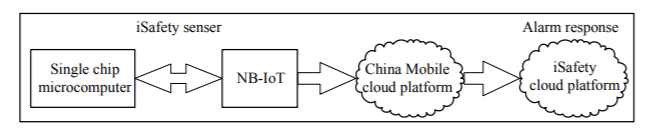
- Uses “iSafety 3.0” sensor
- ‘NB-IoT adopts M5310-A IoT module to access the China Mobile IoT platform, and then sends it to the iSafety cloud platform through mobile platform subscription service, ensuring low power consumption, low cost and long distance data transmission.’ (p 92)
Development of a distributed hybrid seismic-electrical data acquisition system based on the Narrowband Internet of Things (NB-IoT) technology
– Li et al, 2019
- Study undertaken in China
- Seismic and electrical exploration commonly used for prospecting of oil and gas, groundwater and geothermal resource exploration, and urban underground pipeline detection.
- NB-IoT used ‘within a high-precision distributed and wireless hybrid seismic-electrical data acquisition system, which could be controlled and monitored in real time’ (p 178)
- NB-IoT chosen as it is power and cost effective, can provide deep coverage, and supports a large number of connections across significant distances (Dong and Nie, 2017 in Li et al, 2019)
- The NB-IoT communications system ‘consisted of a device layer, network layer, IoT platform layer, applications layer, and management layer. Conducive to ensuring a high level of data quality and operational efficiency’ (p 183)
Shallow landslides and debris flow – KlimaDigital 2019 project
IoT-Based Strategies for Risk Management of Rainful-Induced Landslides: A Review
– Oguz et al 2019
- Norway
- Project aims to use a geohazards assessment framework (GAF) through development of:
- Advanced technology for real-time monitoring of geohazards
- Improved geohazards and climate prediction models
- Novel technical/economic opportunities
- Involves research industries SINTEF, NTNU, and MET, industry partners Nordic Semiconductor, Telia, and Geonor, and public partners NVE and NPRA. Project supported by Research Council of Norway.
- Website: https://www.sintef.no/projectweb/klimadigital/
- Oguz et al (2019) identify that ‘the KlimaDigital project investigates the applications of environmental IoT for monitoring rainfall, soil moisture, pore water pressure, and displacements with cost-effective, low-power NB-IoT’ (p 735)
Bridge Health Monitoring via Displacement Reconstruction-Based NB-IoT Technology
– Thedy et al 2020
- Multiple experiments undertaken with Wenzhou Bridge, Taipei city, used for full implementation.
- Continuous monitoring of bridge through MEMS Accelerometer – ADXL355 acceleration sensor proposed
- Displacement reconstruction algorithm proposed within the study
- NB-IoT used to transmit data from bridge to server
- ‘The acceleration sensor ADXL355 is mounted to Nordic Semiconductor nRF9160…[which] is equipped with… LTE with bandwidth 700-960 MHz and 1710-2299 MHz that will send the signal to base transceiver station (BTS) and to the off-site server.’ (p 9)
Remote monitoring of industrial drives with NB-IoT technology
– Kanerva, 2018
- Thesis analyses the application of NB-IoT for industrial process monitoring [monitoring movement]
- ‘Any automated industrial process must move’, and ‘industrial drive is a machinery, which allows to run the motor at the different speed depending on requirements of the industrial process’ (p 12)
- ‘Advanced monitoring technologies are needed to provide efficient performance and safety of production’ (p 23)
- Two testbeds developed in order to study the use of NB-IoT which shows that there is an opportunity for its use for dense production monitoring with multiple sensors, and extended coverage and battery lifetime
- Also identifies benefits of NB-IoT for rural areas due to extended coverage and battery lifetime
Summary
Effective coastal management requires monitoring of the erosion and evolution of the coastline in order to determine best management practices (Bartolini et al, 2018; Pozzebon et al, 2018). There are examples, as outlined above, of IoT network systems being deployed as part of studies to monitor coastal erosion, however, on the most part this has been limited. Within the category of IoT network systems, NB-IoT does not seem to have been used as part of a network to monitor coastal erosion. In contrast, there is research which documents the use of NB-IoT for effectively monitoring movement ranging from landslides to bridge degradation due to the technology providing long battery life, easier deployment, and supporting high connection density. Some of these NB-IoT networks have been successfully trialled, and thus showcase that such networks provide a useful framework for obtaining the data needed for effective management and for providing alerts in the case of hazards.
Research indicates that the UK coastline is becoming more vulnerable to erosion including cliff falls due to the effects of climate change (Masselink et al, 2020; Karunarathne et al, 2020). The South West Coast Path Association has recorded 180 ‘exceptional coastal erosion events’ since 2013 which have destroyed parts of the 630 miles of South West Coast Path, and further erosion is expected due to climate change (SWCPA, 2020: NP). In order to fully understand how the coastline is being impacted and how best to manage these areas now and in the future, it is important to gain place specific understandings of coastal evolution (Masselink et al, 2020). With NB-IoT coverage expanding, and as it becomes more cost effective, there is an opportunity to combine the knowledge from using IoT network systems for coastal monitoring and from employing NB-IoT networks for monitoring environmental movement. By drawing together the lessons learned from these two categories of IoT network systems deployment, there is a clear opportunity to improve understanding of coastal erosion by using NB-IoT.
Further Information:
Daisy Curtis & Dave Happy
D.Curtis@exeter.ac.uk & MD@telint.biz
References
Bartolini, S., Mecocci, A., Pozzebon, A., Zoppetti, C., Bertoni, D., Sarti, G., Caiti, A., Costanzi, R., Catani, F., Ciampalini, A., and Moretti, S. (2018) Augmented Virtuality for Coastal Management: A Holistic Use of In Situ and Remote Sensing for Large Scale Definition of Coastal Dynamics. ISPRS International Journal of Geo-Information 7(3): 92.
IPCC, (2019), Chapter 4: Sea Level Rise and Implications for Low-Lying Islands, Coasts and Communities, Special Report on the Ocean and Cryosphere in a Changing Climate
Kanerva, T. (2018) Remote monitoring of industrial drives with NB-IoT technology.
Karunarathne, S. M., Dray, M., Popov, L., Butler, M., Pennington, C., and Angelopoulos, C. M. (2020) A technological framework for data-driven IoT systems: Application on landslide monitoring. Computer Communications 154: 298–312.
KlimaDigital (n.d.) KlimaDigital. Accessed: 3rd February 2021 <https://www.sintef.no/projectweb/klimadigital/. >.
Li, W., Zhang, Q., Zhang, Q., Guo, F., Qiao, S., Liu, S., Luo, Y., Niu, Y., and Heng, X. (2019) Development of a distributed hybrid seismic–electrical data acquisition system based on the Narrowband Internet of Things (NB-IoT) technology. Geoscientific Instrumentation, Methods and Data Systems 8(2): 177–186.
Masselink, G., Russell, P., Rennie, A., Brooks, S., and Spencer, T. (2020) Impacts of climate change on coastal geomorphology and coastal erosion relevant to the coastal and marine environment around the UK. MCCIP Science Review 2020 : 32 pages. doi:10.14465/2020.ARC08.CGM.
Matin, M. A., and Islam, M. M. (2012) Overview of Wireless Sensor Network. Wireless Sensor Networks – Technology and Protocols. doi:10.5772/49376.
Marsh, S., (2021), Jurassic Coast cliff collapses in biggest UK rockfall for 60 years, The Guardian, [online website], accessed: 29/04/2021, Available at: <https://www.theguardian.com/environment/2021/apr/15/jurassic-coast-cliff-collapses-in-biggest-uk-rockfall-for-60-years>
Oguz, E. A., Robinson, K., Depina, I., and Thakur, V. (2019) IoT-Based Strategies for Risk Management of Rainfall-Induced Landslides: A Review. In Proceedings of the 7th International Symposium on Geotechnical Safety and Risk (ISGSR 2019). Presented at the Proceedings of the 7th International Symposium on Geotechnical Safety and Risk (ISGSR 2019) Research Publishing Services doi:10.3850/978-981-11-2725-0-IS13-2-cd.
Pozzebon, A., Cappelli, I., Mecocci, A., Bertoni, D., Sarti, G., and Alquini, F. (2018) A Wireless Sensor Network for the Real-Time Remote Measurement of Aeolian Sand Transport on Sandy Beaches and Dunes. Sensors 18(3): 820.
Senfaute, G., Duperret, A., and Lawrence, J. A. (2009) Micro-seismic precursory cracks prior to rock-fall on coastal chalk cliffs: a case study at Mesnil-Val, Normandie, NW France. Natural Hazards and Earth System Sciences 9(5): 1625–1641.
Senouci, M. R., and Mellouk, A. (2016) Deploying Wireless Sensor Networks: Theory
and Practice. Elsevier.
SWCPA, (2020), Businesses join forces to protect the Coast Path against climate change, [online article], accessed: 08/02/2021, < https://www.southwestcoastpath.org.uk/newsapp/article/358/>
Thedy, J., Liao, K.-W., Tseng, C.-C., and Liu, C.-M. (2020) Bridge Health Monitoring via Displacement Reconstruction-Based NB-IoT Technology. Applied Sciences 10(24): 8878.
Westoby, M. J., Lim, M., Hogg, M., Pound, M. J., Dunlop, L., and Woodward, J. (2018) Cost-effective erosion monitoring of coastal cliffs. Coastal Engineering 138: 152–164.
Xie, M., He, Z., Liang, L., Wu, Z., and Sun, G. (2019) Slope disaster monitoring and early warning system based on 3D-MEMS and NB-IoT. In 2019 IEEE 4th Advanced Information Technology, Electronic and Automation Control Conference (IAEAC) (Vol. 1). Presented at the 2019 IEEE 4th Advanced Information Technology, Electronic and Automation Control Conference (IAEAC).
Yan, Y., Yang, D., Geng, D., Hu, S., Wang, Z., Hu, W., and Yin, S. (2019) Disaster reduction stick equipment: A method for monitoring and early warning of pipeline-landslide hazards. Journal of Mountain Science 16(12): 2687–2700.
